A National Model for Estimating US Public Land Visitation
Citation
Merrill, N., Winder, S. G., Hanson, D., Wood, S. A., & White, E., 2024. “A National Model for US Public Land Visitation,” SocArXiv, Center for Open Science. doi.org/10.31235/osf.io/avjue
Understanding how many people public lands is important for protecting nature and improving visitor experiences. Accurate visitor counts help land managers reduce environmental damage and show the value of the services that natural areas provide.
In this study, researchers built and tested computer models that estimate how many people visit public lands such as national parks, forests, and wildlife refuges. These models used different types of digital data that show where and when people go outdoors (e.g., social media posts, recreation website posts, and anonymous cellphone location data).
Researchers compared the model predictions with real visitor counts collected by the U.S. National Park Service, Forest Service, and Fish and Wildlife Service. The models worked best when real, on-site visitor data was included along with the digital information. This helped the models adjust for differences among parks and between the agencies that manage them.
Researchers also found that using several digital data sources together gave more accurate results than relying on just one source.
These findings can help public land managers use digital information more effectively to estimate visitation and make better decisions about managing and protecting these important places.
Abstract

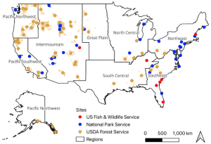
show unit boundaries for units which are larger than the points.
Public land management relies on accurate visitor counts in order to understand and mitigate environmental impacts and to quantify the value of ecosystem services provided by natural areas. We built and tested predictive visitation models suitable for publicly-managed parks, open space and other protected lands based on multiple sources of digital mobility data including posts to social media, recreation report platforms, and a cellular device location dataset from a commercial vendor. Using observational visitation data series from the United States’ National Park Service, Forest Service and Fish and Wildlife Service, we quantified the accuracy of statistical models to predict on-the-ground visitation using individual and combined sources of locational data. We found the predictive models performed best in settings where some on-site visitation data can be integrated into the models. On-site visitation data helps to account for meaningful differences in modeled relationships both within and across the three agencies considered. We found variation in the usefulness of the digital mobility data sources, with models combining multiple data sources outperforming those using a single source, including those based solely on cellular device locations. We discuss the practical implications of these findings as well as paths forward to improve visitation estimation on public lands by incorporating digital mobility data.