Fine-Scale Maps of Nature-Based Recreation
Researcher: Spencer Wood
Data on recreational use are critical for evaluating proposed policies and management options for public lands. On-site counts and intercept survey programs provide invaluable information on the amount and character of recreation use on public lands, but they are limited by the time and expense required to survey visitors. Additionally, the timeline to inform policy and management is often too short to wait for new data collection.
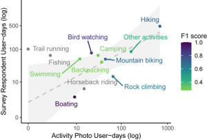
To aid governments and community organizations who see increasing and varying demand for outdoor recreation, we are innovating the use of crowd-sourced data and volunteered information from social media users and citizen scientists as fertile data on recreation. The Outdoor R&D team researches ways to mix big digital data streams with traditional data sources in order to map and measure public land use more efficiently, and at finer spatial and temporal scales. We have shown through years of research in diverse settings worldwide that the locations of photographs that are uploaded to photo-sharing websites such as Flickr and Instagram are reliable sources of data on the numbers of visitors, and these methods can be scaled up to study many destinations and points in time.